Which raindrop caused the flood?

KW_seiner RW
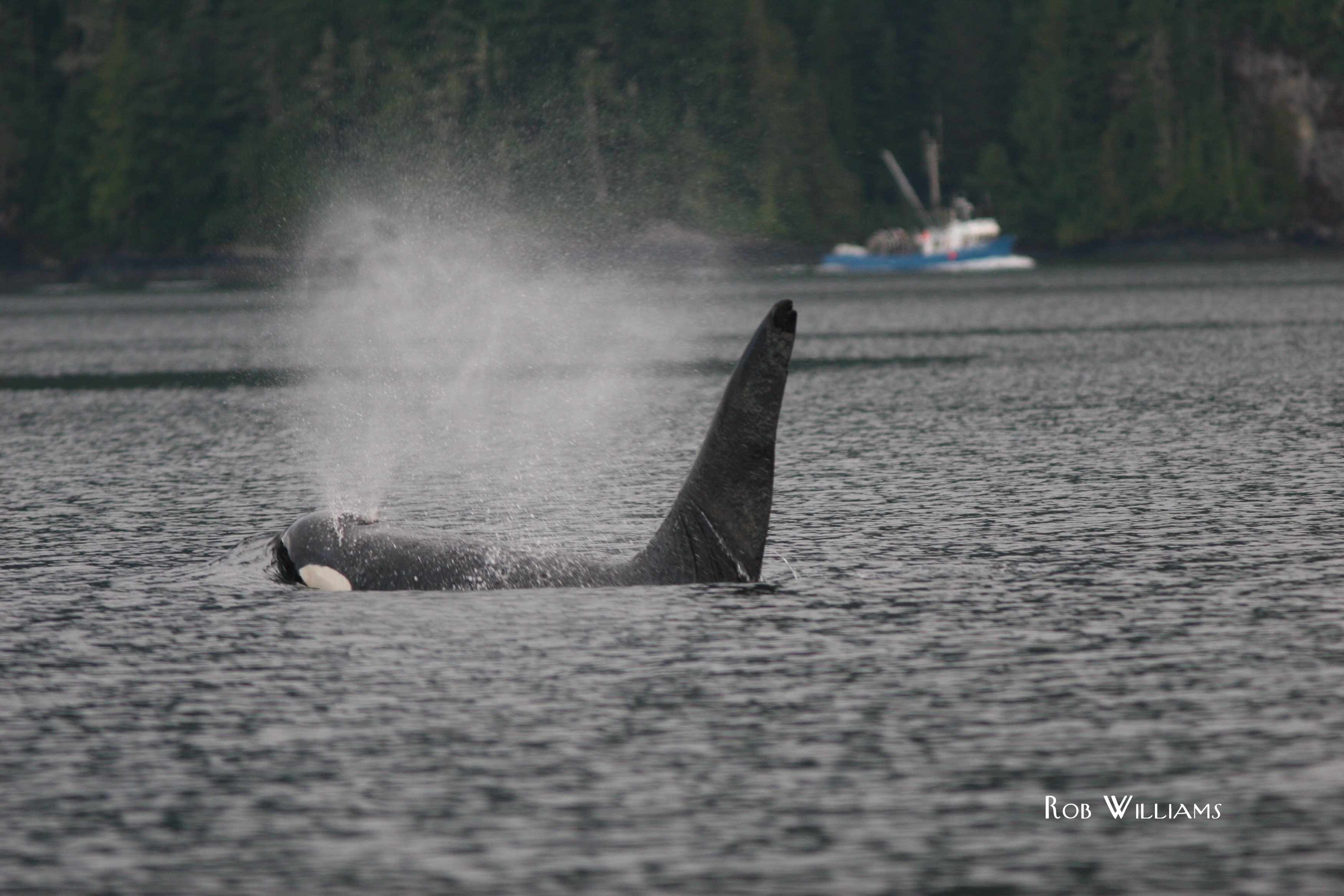
A lot of the research our charity, Oceans Initiative, conducts is to see how human activities — all of them — affect marine wildlife, both in the Pacific Northwest and around the world. The iconic orca we study illustrate this problem well. According to the latest census by Center for Whale Research, the population is hovering at 84 individuals. The original problem was a live capture fishery for display in aquaria, with all the direct and collateral damage that entailed. But why aren’t they recovering, nearly 40 years after the captures stopped? Regulatory agencies in Canada and the US agree:  it’s a combination of lack of prey (Chinook salmon), too much noise, and chemical pollution.  Some of these threats are much easier to manage in the real world than others. But are we focusing on the right threats?

In our field, this thorny problem is described as “cumulative impacts of multiple anthropogenic stressors.” Clumsy, right? Our colleague, Dr David Bain, described it better:  Which raindrop caused the flood? 

It’s really, really hard to predict how wildlife populations will respond to a minefield of too much ocean noise, not enough food and a body full of chemicals. Think about that for a moment. The blubber that whales put on to survive — used by mothers to make milk for their young — is full of toxic chemicals, and the best way for a whale to detox is to transfer those pollutants to their offspring. Not great for the calf. Adult males don’t even have that option. And if you’re honest about the uncertainty in all the steps and how they fit together, your predictions span the entire range from no effect to catastrophic effects.

Our newest research proposes a way around it.  Start at the end.  Start by asking how much impact on endangered whale populations that our laws allow, and work backwards to calculate how much perturbation (noise, competition with fisheries) it would take to get there.

This approach doesn’t solve the problem, but it helps identify the problem, and the math is easier. For some critically endangered species, policy-makers may not want to allow ANY impact on a population. For healthy, growing populations, our laws allow some impact on marine mammal populations, because humans use the ocean too: for fishing, shipping, recreation, tourism and extracting energy. Our approach gives us a rough, ballpark estimate of what a healthy population can withstand.  Then, you can convene a group of scientists, managers and stakeholders to ask how likely it is that the sum total of all current and proposed activities could cause us to be exceeding that threshold.

There are a number of places around the world where this sort of exercise is needed.  As we try to ensure whale and dolphin populations recover from the Deepwater Horizon incident, it would be good to look at the cumulative effects of all activities, including seismic surveys, in the Gulf of Mexico. As we discuss opening new parts of the Arctic to oil and gas activities and shipping, we can use this method to test whether all of those activities, together, could affect food security of communities living in the Arctic. As we consider the number of industrial developments for the British Columbia coast — ports, liquefied natural gas terminals, pipelines and tanker traffic proposals — it may be time to consider how all of these factor may affect whale and dolphin populations. Some are doing fine. Others are barely hanging on. Our new tool can give us a starting point for discussion how much is too much.

We loved writing this paper with Dr Christopher Clark (an acoustician at Cornell University), Dr Len Thomas (a statistician at the University of St Andrews), and Prof Philip Hammond (a marine mammal population ecologist at the University of St Andrews).  Please check out the #openaccess paper on the website of the journal, Marine Policy:

Gauging allowable harm limits to cumulative, sub-lethal effects of human activities on wildlife: A case-study approach using two whale populations

Counting and protecting Amazon river dolphins

Did you know two species of river dolphin‬ live in the Amazon‬? The pink one is called boto‬, or Inia; the grey one is called tucuxi‬, or Sotalia. Both are gorgeous, ancient species that have become adapted to live their entire lives in freshwater. They are also incredibly tough to spot in muddy waters, and have a cryptic behaviour that makes them difficult to count.

That’s a problem, because a key task in‪ ‎conservation‬ science‬ is knowing whether a species is increasing or decreasing.

We partnered with scientists at Fundación Omacha, University of St Andrews & NOAA to survey river dolphins in a stretch of the Amazon at the border of‪ Colombia‬ & Peru‬. Using some simple field methods [learn more about our small-boat survey toolkit here] & fairly sophisticated analytical methods, we found that tucuxi is likely to be stable or increasing, but boto are likely to be declining.

Our findings are worrisome, given reports from‪ Brazil‬ that there is a major problem with deliberate killing of boto for bait in a lucrative catfish fishery. Our next steps are to (a) continue surveys withFundación Omacha to improve our understanding of seasonal and annual trends; and (b) work with Dr Fernando Trujillo (founder of Omacha) to identify solutions. If poaching is the problem, we can work toward finding alternative sources of fish bait. Dr Trujillo points out that more than 150 major hydroelectric dams are proposed for Amazonia. These would fragment dolphin habitat, and our research shows that we have very low statistical power to detect declines — possibly until they become irreversible.

Want to learn more?

Please check out our video describing the project and showing the animals swimming through flooded rainforest (underwater footage courtesy BBC Natural History Unit).  Science Magazine wrote a news article describing our work — a first for our team.  And of course, let us know if you’d like to read the original, technical paper published in Biological Conservation

COUNTING WHALES IN A CHALLENGING, CHANGING HABITAT

Antarctic minke whale surfacing in front of a tabular iceberg along the western Antarctic Peninsula


Few marine conservation issues are more contentious than Japan’s “scientific whaling” program, which allows for the killing of up to 935 whales each year. This number is large, relative to hunts of other whales in other parts of the world, but small relative to the hundreds of thousands of Antarctic minke whales in the population.

To many conservation scientists, though, it’s not the absolute number of whales in the population that matters — what we care about is whether the population is going up or down.  And we’ve known for more than a decade that the Antarctic minke whale population appears to be declining.

That’s bad.  But if the whales’ sea ice habitat is being affected by global climate change, its long term trajectory may be even worse.  That would make Antarctic minke whales an icon of climate change — a Southern Ocean counterpart to the polar bear in the Arctic.  One problem:  Antarctic minke whales are even more difficult to count than polar bears.

That’s the context in which we partnered with the German and Dutch Antarctic programs, with input from British, American and Australian scientists.  We conducted the first icebreaker-supported helicopter surveys in open water and adjacent ice-covered waters along the edge of the sea ice in the Weddell Sea.  Our study found that there is a high density band of whales just along the ice edge, where ship surveys are confounded by fickle navigational safety issues.  That region is home to high concentrations of the whales’ favourite food, krill.  That region is being affected by climate change in different ways in different regions of the Southern Ocean.  And maddeningly, just as we are beginning to understand the threat, changing ice conditions may be changing the surveys we use to monitor the health of the whales’ population.  Depending on the ice conditions on a given day, a ship may or may not be able to access this high density region.  And that affects our ability to tell if the population is going up or down.

Australia is suing to end Japan’s special permit whaling.  The International Court of Justice will announce its decision tomorrow.  Regardless of that decision, our research shows that if we really want to know how this population is being affected by climate change, we need bigger and much more expensive surveys than ever before.

A Rare Visit


Grey whales are pretty neat.  We were lucky enough to encounter two of them on Boxing Day.  Their visit to inshore waters of British Columbia in December was a bit of a surprise.  Grey whales are legendary for their migration, which is among the longest of any mammal.  We’d expect to see grey whales in spring and fall as they make their annual trip between Mexico and Alaska.  But it’s December, so we were surprised to find that these two were in front of our field cabin rather than in Mexico with the rest of their family.

It seems grey whales are full of surprises.  Our colleague, Bruce Mate, at the Hatfield Marine Science Center at Oregon State University, has tagged several individuals from the highly endangered Eastern North Pacific grey whale population off Sakhalin Island in Russia.  One whale, now known as Flex, traveled from Russia to the Oregon Coast when its satellite tag stopped signaling.  In 2012, another whale called Varvara, traveled from Russia to Mexico in two months!

Have you seen Big Miracle with Drew Barrymore and John Krasinski?  If you haven’t, you might want to check it out.  Based on a true story, the movie tells the tale of three grey whales that became trapped in the ice off Barrow, Alaska.

Anyway, we felt pretty lucky to photograph these two whales and are sending our ID photos to colleagues to see whether we can find a match in their extensive catalogs.  Unique markings on grey whales (the pigmentation patterns on the flukes and flanks (sides) of the whales, as well as the knuckles on the back) offer clues to help identify who the whales are and where else they’ve been.  We’ll keep you posted on whether our colleagues find a match.

Meanwhile, we’re still hoping to find Pacific white-sided dolphins when the winds die down.  We hope you’ve had a great holiday season, and we look forward to having a lot of results from our ocean noise and dolphin studies to report in 2013.

WHERE THE WHALES (AND WHALE RESEARCHERS) ARE


A global summary of where researchers have published density estimates for whales, dolphins and porpoises (from Kaschner et al. 2012)

Rob and his colleagues published a neat new paper today in the open access journal, PLOS ONE.  The paper, led by Dr Kristin Kaschner at the University of Freiburg, examined >1100 estimates of the abundance of whales, dolphins and porpoises reported in more than 400 surveys conducted worldwide between 1975 and 2005.

It is hard to convey how boring science can be sometimes.  

During the research, the team digitized thousands of maps, so you don’t have to.  Seriously.  Kristin made the data for the map (above) available for download, in case you ever want to do a global analysis of where people have and haven’t surveyed for whales.  Here’s what was learned about the global patchiness of whale and dolphin research.  Overall, only 25% of the world’s ocean surface has been surveyed at all, while only 6% has been covered well enough to offer any hope of detecting trends in population size.  Other findings included:

  • The vast majority of surveying effort has taken place in waters under the jurisdiction of wealthy, northern hemisphere countries like the US, Canada and Europe.
  • Southern hemisphere regions are underrepresented, except the Antarctic, where the International Whaling Commission leads surveys to estimate abundance of the Antarctic minke whale, which is subject to scientific whaling by Japan.
  • Few surveys have taken place in high-seas waters beyond national jurisdiction.  This hinders global initiatives to implement high-seas marine protected areas that reflect the habitat needs of whales and dolphins.
  • The level of survey effort conducted in the eastern tropical Pacific may look excessive but is actually at the low end of what is needed to detect population trends.
  • The main focus for surveying populations was in tuna fishing regions due to the market for “dolphin-friendly” tuna, with more surveys in the eastern tropic Pacific Ocean than in the rest of world combined.

Our ability to protect cetaceans from threats such as military sonar, seismic surveys (for offshore oil exploration), oil spills or bycatch in fisheries hinges on good information, and this latest research indicates a lack of baseline information to evaluate threats across the vast majority of the world’s oceans.  As international efforts are underway to protect global biodiversity, the researchers conclude there is an urgent need to develop new methods to fill in data gaps which can in turn improve marine conservation efforts.


Here are some quotes from the authors:

Dr Nicola Quick, co-author and honorary research fellow from the University of St Andrews, commented: “One of the primary motivations for our research was to know where whales might be most vulnerable to the use of military sonar or seismic surveys to find oil under the seabed. The enormous data gaps we found in our study remind us that we still have a lot of work to do to predict whether vulnerable species might be using the waters that have never been surveyed.  We recommend international coordination of surveys to share resources to fill in these gaps.”

When looking at the coverage in the eastern tropical Pacific, Kristin noted that “the rest of the world has a lot of catching up to do if we want to know if whale populations are recovering from historic whaling or bycatch in fisheries. The issue of data gaps pervades every issue in marine planning, from fisheries management to marine protected areas.  Because of the strict science needs of whaling, the information available on whales and dolphins may paint an optimistic picture of marine science.  Knowledge gaps are almost certainly worse for deep-sea invertebrates, sharks or marine viruses.”

Oceans Initiative co-founder, Dr Rob Williams (who is also a Researcher in the Sea Mammal Research Unit at the University of St Andrews) added: “One of the most important management and conservation decisions we make is how to allocate scarce funding for research.  As we aim to protect marine biodiversity on a global scale, we need to ensure that our scientific advice reflects the fact that the vast majority of the world ocean has never been surveyed in a comprehensive way. If we ignore that, our advice is biased toward coastal waters of wealthy countries, and that is unjust.”